Giter Site home page Giter Site logo

osmscout-sailfish's Introduction

OSM Scout for Sailfish OS

Last build on Ubuntu 20.04 Last build on Ubuntu 22.04 Flattr this project Donate via PayPal.me Donate using Liberapay

Goal of this project is to bring offline maps and navigation to Sailfish OS with native look and feel. OSM Scout for Sailfish OS is based on OSM Scout library.

Standard style Winter Sports style Track detail

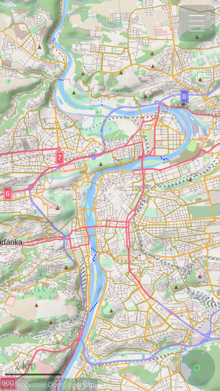
You can choose one from multiple map styles: standard, outdoor, public transport or winter sports. All with the same database that can be downloaded (per state) directly from the application for offline usage. Data on the server covers whole planet and are updated monthly from OpenStreetMap data. You can generate your own extract eventually, all tools are open-source and OpenStreetMap data are free!

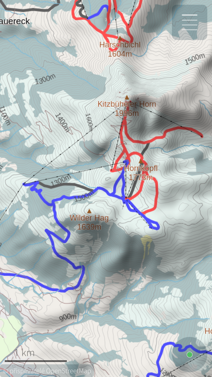
For better outdoor experience, databases (almost all) contains elevation contours and hillshade overlay (online) can be displayed.
For areas not covered by offline data are used online maps provided by OpenStreetMap or Stamen Design. But search and navigation works only with offline data.

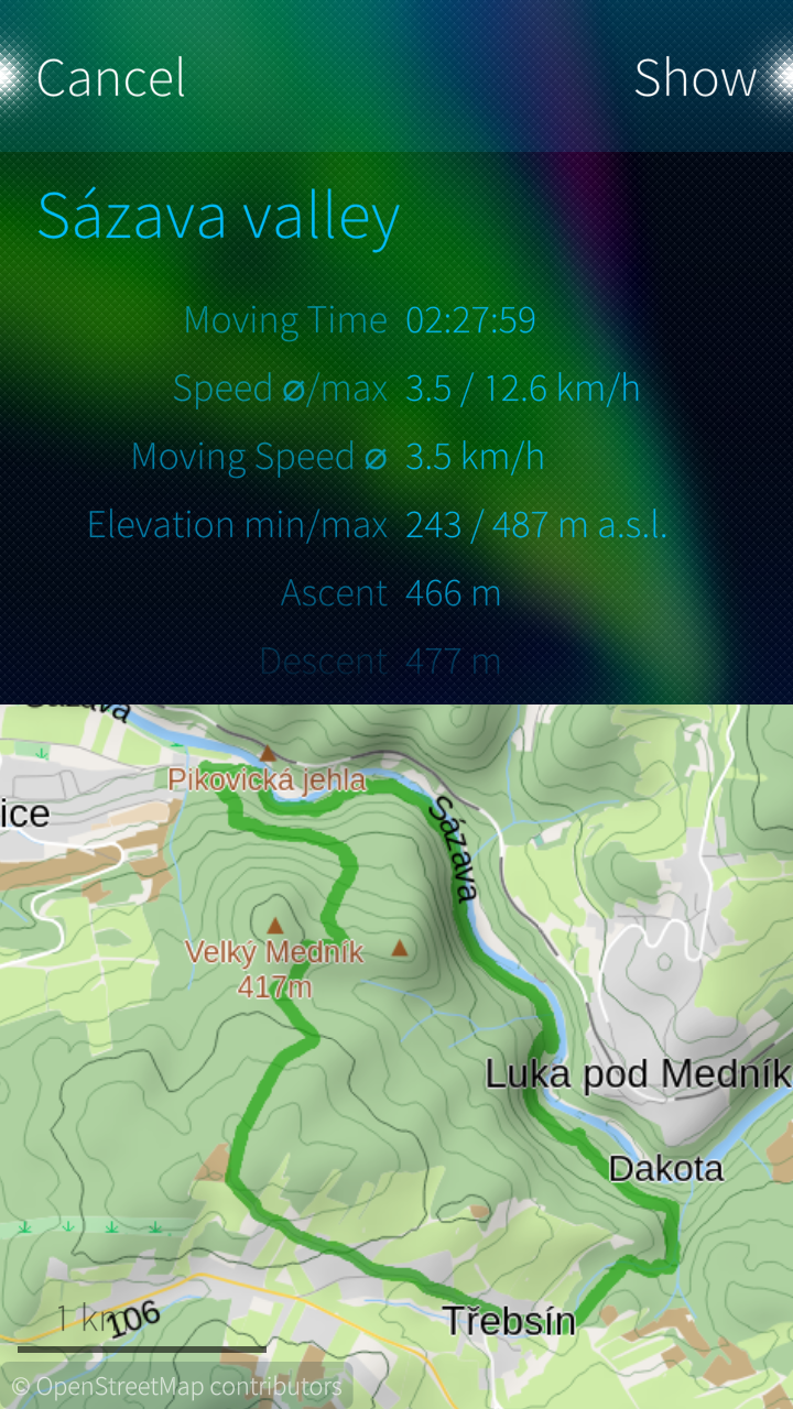
Your favourite places (waypoints) can be stored to collections and exported to GPX files later. It is even possible to import tracks and waypoints from GPX files, display it on map or show simple statistics.

You can help to improve this application by reporting bugs, creating translations or developing new features. Any help is welcome!

Project Wiki:

osmscout-sailfish's People

Contributors

1zgp avatar abtinmo avatar atlochowski avatar carlosgonz0 avatar derdakon avatar dikonov avatar eson57 avatar framstag avatar grypho avatar karry avatar kit-ty-kate avatar martonmiklos avatar mepahoo avatar ogretransporter avatar pawelspoon avatar phhorrein avatar threepistons avatar umglurf avatar vyskocil avatar

Stargazers

 avatar  avatar  avatar  avatar  avatar  avatar  avatar  avatar  avatar  avatar  avatar  avatar  avatar  avatar  avatar  avatar  avatar  avatar  avatar  avatar  avatar  avatar  avatar  avatar  avatar  avatar  avatar  avatar  avatar  avatar  avatar  avatar  avatar  avatar  avatar  avatar  avatar  avatar  avatar  avatar  avatar  avatar  avatar  avatar  avatar  avatar  avatar

Watchers

 avatar  avatar  avatar  avatar  avatar  avatar  avatar  avatar

osmscout-sailfish's Issues

Possibility to add some sentences to translate

  • Sentence: Route! showed in the picture
    captura_20170726_001
  • Sentence: All showed in the pictute
    captura_20170726_002

Karry can you change "Routing"to "Calculating the route".THIS SENTENCES IS ONLY SHOWED WHEN I TRY GET A LONG ROUTE , then show this sentence. Note than the sentence routing exist in two time ,but i think this "Routing" sentence it is better to change to "Calculating the route" = )

AppSettings missing

I pulled the last version of the code, and it seems that AppSettings.h and AppSettings.cpp are missing. Could you commit them ?

Pierre-Henri

Path to arbitrary point on the map

In the forest no chance set named destination point, need set arbitrary point - at forest marge, unnamed road, etc.

Best solution - sound signal when distance to that point grow or not decrease in 5 minutes. I think it will be killer feature for forrest tourists.

Navigation voice commands

It would be useful to have navigation commands. There are multiple options how to do it - use some TTS tool, like Poor Maps or build commands from real-voice samples. I prefer second option, it sounds more natural. Voices from "voice of marble" project can be used as for the start.

Some parts of code (complete?) will have to be implemented in core library. It would be better to wait for navigation re-implementation Framstag/libosmscout#443 ...

automatic night mode for navigation

it would be nice to use night mode automatically for navigation in tunnel and at night. It should be easy to implement:

  • navigation already know when car is in tunnel
  • algorithms for sunset / sunrise can be found on the internet
  • night flag exists in stysheet model already

navigation is not translated in 100%

When I start navigation, information about distance is translated to OS language but direction commands are in English.
It's weird because all direction commands are translated in language files.

Do not delete old maps after downloading new ones

When I download for example new version of map of Poland I will have two versions in Document directory. Which is not good. After couple map updates memory of the phone will finish.
I think you should consider deleting old version of maps when downloading of new ones is finished.

RPM build errors

Hi,
i want to run this demo on emulator.
when i build osmscout for sailfish according this Wiki.
https://github.com/Karry/osmscout-sailfish/wiki/Howto-build-for-Sailfish-OS

it turns out these error:
+ cp /usr/lib/libgomp.so.1 /home/deploy/installroot/usr/share/harbour-osmscout/lib/
cp: cannot stat `/usr/lib/libgomp.so.1': No such file or directory
error: Bad exit status from /var/tmp/rpm-tmp.G2aGkw (%install)

It has same error on my mac OS X 10.13.3 and windows 10;

then i try to install openMP on OS X, but also failed.
brew install clang-omp,

also installed llvm refer following link, but no luck.
https://stackoverflow.com/questions/38971394/brew-install-clang-omp-not-working

here are files produced after mb2 -t SailfishOS-i486 build
[mersdk@SailfishSDK rpmbuilddir-i386]$ ls
CMakeCache.txt MultiDBRouting_automoc.cpp Routing_automoc.cpp cs.qm es.qm hu.qm nb.qm privateinclude
CMakeFiles PerformanceTest SearchPerfTest de.qm fr.qm install_manifest.txt nl.qm sv.qm
Makefile PerformanceTest_automoc.cpp SearchPerfTest_automoc.cpp dependencies harbour-osmscout libmarisa.a nl_BE.qm
MultiDBRouting Routing cmake_install.cmake en.qm harbour-osmscout_automoc.cpp moc_AppSettings.cpp pl.qm

how to fix this error and build rpm packet?
Any reply will be grateful!

No rendering of areas near map borders

OSMscout 0.19.0 and 0.20.0 do not render a strip (of varying width from a few to ~ 50 km) along map borders.
Additionally the rendering of the Netherlands from Castricum (in Noord-Holland) / Alkmaaar northeast-bound all along the north sea coast (until hitting the German border) is severely broken. This may be linked to the first issue (as this also is along a map border).
Note that Modrana with OSMscout Server does not exhibit either issue (with the same maps), but is unable to display more than a single map. So while the whole map is displayed correctly in Modrana, one has to switch the map in OSMscout Server to peek across a (map) border. Being able to display multiple offline maps (without switching) is basically a big plus for OSMscout, if only this feature would be working flawlessly.
Tested on a Jolla 1 phone under SailfishOS 2.0.5 and 2.1.0 with maps (NL, LUX, DE; all dated 2017-03-27) for libosmscout downloaded with OSMscout Server's Map Manager.

featureRequest: revamping aboutPage

like this the aboutPage, also deleting the strings "AboutPage" of this page it is not more needed : )
also with this FR will close issue #99

            OSMScout
                V: 2.0.0

a example here how look like the new desing by using PodQast-app as example , pureMaps- rinigus is already for it. so what you think karry on it?
podcast
OSMscout
OSMSCot
Uploading OSMSCot.png…

Build for local development

While building for arm or i486 target works fine, building for local development does not work for me.

After installing the qt dependencies, I got this error after the cmake line from the Readme:

-- Requiered dependencies:
-- Qt5 found................................ YES
-- OpenMP compiler support found............ YES
-- SailfishApp library found................ NO
CMake Error at CMakeMod/MacroUtils.cmake:44 (message):
SailfishApp library is needs. You need to install the SailfishApp library development package.
Call Stack (most recent call first):
CMakeLists.txt:89 (PRINT_LIBRARY_STATUS)

Can't open routing service...

Routing still don't work for me. I get "Can't open routing service" whatever I try. Error message is also untranslated as you can see, and why do I have to wait 10 sec. before I DON'T get service? ;-)

screen_20180430_001

search does not work (without offline map)

i think to remember an issue with search, but could not find it. so i am opening a new one.
tried to search for city: Salzburg, Graz, no results. salzburg deto, street in Salzburg also nothing. should this work already ? i have no downloaded maps yet. austria might be 20percent downloaded

mapsDownloader

i having issues to updating or downloading maps, not sure if it is for new release or before.
thanks.

Can't seem to 'Import' map data for offline use

App info states that to use offline maps, one may follow the instructions given here.

I put the .osm.pbf file in the Documents\Maps\ directory, but I don't understand how I can follow the rest of the instructions. There isn't any 'Import' folder anywhere on the phone, and what build.sh script?

Is it that the import feature hasn't been integrated, or am I missing something?

slow rendering of a map

I am not sure its a right time (in terms of development) to report this issue. However, its probably a right channel (github) to get your point of view on that.

First, thank you very much for developing this program - it surely has a great use!

So, on Nexus 4, SFOS 2.0.2.48, I get a map rendered at about 12 seconds on zoom level 16 (default) in rather sparsely populated area. Is this an expected result?

I used a git repo clone from today to check if its fixed already. Looked a bit into the source, tried few things in the options for db, but not much success.

Best wishes,

rinigus

PS: please let me know if you need any details or this is a common issue.

Custom directory for offline maps (or ones compatible with OSM Scout Server)

Oh, seems that one cannot reopen an issue, when not being the owner, or the one, who originally opened the issue. So in continuation of issue #14:

With the update from OSM Scout Server 0.6.2 to 0.7.0 (and newer), it became impossible to share the offline maps with OSM Scout (0.19 used; both installed from the Jolla Store) via their GUI-based settings. Both have fixed, incompatible directory names now, i.e. <chosen-OSMScoutServer-dirname>/osmscout for OSM Scout Server (0.7.0 and higher) and either ~/Documents/Maps or <SDcard>/Maps for OSM Scout.
Hence please implement a setting in OSM Scout to freely choose a directory for the offline maps or make the two preselected directories compatible with OSM Scout Server's map-directory scheme, e.g. make it a "~/OSMscout/osmscout and <SDcard>/OSMscout/osmscout"-pulley. IMO ~/Documents is not the right place for putting huge offline maps files anyway, instead a separate directory in ~ fits better.

Maps for Mayotte and Martinique missing

Hi there,
after the last update, I am updating French/* maps. But the system fails at downloading the updates for Mayotte and Martinique, even though they are in the list to be updated.

Thanks,
Cheers.

Feature request: imperial distance units

As a British user (also applies to Americans).
When I use the navigation feature.
I would like to be able to see the speed and speed limits in miles per hour and the distances in miles and yards.

Allow custom download/import folder

As far i know, currently the data is being downloaded to ~/Documents/maps. It would be nice to support user defined folders to allow e.g. a download and import from SD card.

Crash on long-press

Crash on long-press. Reproduces 100% of the time, tested in many locations, across a few countries. No downloaded maps.

From running OSM scout in the terminal:

[D] unknown:0 - long tap  QPoint(859,987)
[D] onLongTap:272 - long tap: 859x987 @ 58.12509867350767 15.296903446932012
Map DPI override: 192.00000
[D] unknown:0 - Overlay tile cache: osmscout::TileCache(0x9ec6f4)
[D] unknown:0 - Initialize
[D] unknown:0 - ~PlaneMapRenderer
[D] unknown:0 - ~MapRenderer
harbour-osmscout: /home/mersdk/share/SailfishOS/projects/osmscout-sailfish/dependencies/libosmscout/libosmscout/src/osmscout/util/Bearing.cpp:91: std::string osmscout::Bearing::LongDisplayString() const: Assertion `false' failed.
Aborted

1.5 works, subsequent versions have this behaviour.
Let me know if you need more info/logs. Tried building the project, but that doesn't work for me if i do like with normal projects, so couldn't debug the value that falls outside the 0..360 range.

Update imported maps ?

Is imported map data updated when connected to the internet?

I had made some changes in the OSM database yesterday, but they do not seem to be displayed on my map even when I'm connected to the internet (I have this particular area imported for off-line use).

street name trouble

-Problem to display street names as well in the new version v=0.17 - sf=2.0.5.6
-The names of the streets are very small unable to read,even doing zoom.

map server mirror

I can't find your mail so I ask you here. Do you want to have mirror for maps?

osmscount- sailfish; New Icons

HI @Karry
I would like see this app with a nice icons ,high DPI,Highlighted colors,High Precision Edges. So I want to talk to Alain-Molteni to create it ,he is the best on sailfish icons = )

  • I believe in osmScount that It deserve a nice Icon...
  • I will pay the cost for the Icon
  • So I open this ticket to discuss Metaphors? for it

Synchronise collections with cloud storage

As OSM Scout supports collections now (database of waypoints, routes), it would be useful to have possibility to login to some cloud storage (OwnCloud?) that would be used for two-way syncing... Collection may be stored on cloud storage as standard gpx files - we already support collection export/import (to/from gpx)....

Other proprietary map applications from Android world (Here, mapy.cz) supports such synchronizing already...

Update of a map fails due to 'directory already exists'

Hello Karry,
i did try to update a downloaded map today, the remorse time appears with the message that directory does already exist.
no matter if you just wait, or swipe it ways the update does not happen.

I am using you most recent version.

GPX tracks

Will be very interesting if were possible to see GPX tracks over the map.

Disable double tap

Double tap centers on current position.

Can you please disable it or allow disabling it from the preferences? It is really annoying when "looking something up". Especially when this something is far away from the current location.

Thanks a lot for the great app!

Route recording

It would be useful to support track recording (gps tracker). Collections can be used as storage (internal database for routes and waypoints - #37) .

Help with translation

Hi Lukáš,
I'm updating German translation at the moment. But I have one problem:
There are some strings wich contain the word "collection" unfortunately I don't know the context so it's a little bit hard to translate for me.
I have searched in the application, but didn't found, where "collection" is used. So i suppose, it's for an upcoming feature. Can you maybe try to explain in which context the word "collection" will be used?
Thanks
Uli

Impossible to fork original libosmscout

As osmscout-sailfish is a fork of the original libosmscout repository, it is not possible (or at least not straightforward) to also contribute to libosmscout upstream. Since osmscout-sailfish does not use the code anymore, but downloads it as dependency instead, maybe it would be possible to "unfork" the repo ?

Pierre-Henri

Routing fails

I was unable to route from my current location (100m from a major road in a big city) and a manually picked point at a crossroads in the same city. The error message was "Can't find route node near start coord 55.8... N 37.5..."

OSM Scout server can route offline between these locations in modrana and whogo maps, so that must be a bug of the OSM Scout app itself.

german translation

i can help with..
where can i find it?
did not find anything in transifex

Incorrect rendering seas

On the maps offline you can not see the sea. This can be seen on the shore of Croatia, there is no distinction between land and sea.
For rivers and lakes rendering it is correct.
If necessary, I can attach screenshots.

Recommend Projects

  • React photo React

    A declarative, efficient, and flexible JavaScript library for building user interfaces.

  • Vue.js photo Vue.js

    🖖 Vue.js is a progressive, incrementally-adoptable JavaScript framework for building UI on the web.

  • Typescript photo Typescript

    TypeScript is a superset of JavaScript that compiles to clean JavaScript output.

  • TensorFlow photo TensorFlow

    An Open Source Machine Learning Framework for Everyone

  • Django photo Django

    The Web framework for perfectionists with deadlines.

  • D3 photo D3

    Bring data to life with SVG, Canvas and HTML. 📊📈🎉

Recommend Topics

  • javascript

    JavaScript (JS) is a lightweight interpreted programming language with first-class functions.

  • web

    Some thing interesting about web. New door for the world.

  • server

    A server is a program made to process requests and deliver data to clients.

  • Machine learning

    Machine learning is a way of modeling and interpreting data that allows a piece of software to respond intelligently.

  • Game

    Some thing interesting about game, make everyone happy.

Recommend Org

  • Facebook photo Facebook

    We are working to build community through open source technology. NB: members must have two-factor auth.

  • Microsoft photo Microsoft

    Open source projects and samples from Microsoft.

  • Google photo Google

    Google ❤️ Open Source for everyone.

  • D3 photo D3

    Data-Driven Documents codes.