Comments (8)
 mattijn
commented on May 28, 2024
1
mattijn
commented on May 28, 2024
1
TLDR: I think, if you set the shared_coords=False it will work for the above mentioned cases (see https://mattijn.github.io/topojson/example/settings-tuning.html#shared_coords for info).
No solutions for the issue in the strategy shared_coords=True, but a better understanding where it goes wrong. Single touching coordinates are in the shared_coords are used as cutting-points and afterwards the non-shared segments are tried to be merged again into a contagious segment, where possible.
This process doesn't work properly as is proven in this issue and I can reproduce it with two linestrings.
from shapely.wkt import loads
import topojson
from topojson.core.extract import Extract
from topojson.core.cut import Cut
from topojson.core.dedup import Dedup

data = [
    {"type": "LineString", "coordinates": [(1,0),(2,0),(3,0),(4,0),(5,0)]},
    {"type": "LineString", "coordinates": [(5,0),(4,-1),(4,0),(4,1),(3,1),(3,0),(2,1),(2,0),(1,0),(1,1)]},
]

# topojson.Topology(data, shared_coords=False)  # this works (in this case)
topojson.Topology(data, shared_coords=True)
TypeError: 'NoneType' object is not iterable # v1.0rc10 TypeError: cannot unpack non-iterable NoneType object # master
# Extract works
e = Extract(data, options={'prequantize':False})
e.to_svg(separate=True)
# Cut works
c = Cut(data, options={'prequantize':False})
c.to_svg(include_junctions=True, separate=False)
Dedup class fails in https://github.com/mattijn/topojson/blob/master/topojson/core/dedup.py#L115-L146. The function _find_merged_linestring returns nothing.
# 3 out of 4 arcs are detected in te linemerge, but current code only covers 2 of n or n of n
Dedup(data, options={'prequantize':False})
---------------------------------------------------------------------------
TypeError Traceback (most recent call last)
<ipython-input-22-22bbfc364764> in <module>
----> 1 Dedup(data, options={'prequantize':False})
~\Documents\notebooks\topojson\topojson\core\dedup.py in __init__(self, data, options)
25
26 # execute main function of Dedup
---> 27 self.output = self._deduper(self.output)
28
29 def __repr__(self):
~\Documents\notebooks\topojson\topojson\core\dedup.py in _deduper(self, data)
97 # apply linemerge on geoms containing contigious arcs and maintain
98 # bookkeeping
---> 99 self._merge_contigious_arcs(data, sliced_array_bk_ndp)
100
101 # pop the merged contigious arcs and maintain bookkeeping.
~\Documents\notebooks\topojson\topojson\core\dedup.py in _merge_contigious_arcs(self, data, sliced_array_bk_ndp)
236 # get the idx of the linestring which was merged
237 idx_merg_arc, consec_behavior = self._find_merged_linestring(
--> 238 data, no_ndp_arcs, ndp_arcs, ndp_arcs_bk
239 )
240
TypeError: cannot unpack non-iterable NoneType objectIn _find_merged_linestring the following logic should be covered
from IPython.display import SVG, display
from shapely.ops import linemerge

def svg_split_view(geom):
    svg_custom = geom._repr_svg_()
    for c in ['green','blue', 'orange', 'red']:
        svg_custom = svg_custom.replace('stroke="#66cc99"', f'stroke="{c}"', 1)
    display(SVG(svg_custom))

in_geoms = loads('MULTILINESTRING ((5 0, 4 -1, 4 0), (4 0, 4 1, 3 1, 3 0), (3 0, 2 1, 2 0), (1 0, 1 1))')
svg_split_view(in_geoms) # 4 non shared arcs
out_geoms = linemerge(in_geoms)
svg_split_view(out_geoms) # 3 out of 4 can be merged
The issue is in the process when the remaining non-shared arcs are tried to be merged again.
In this process (_find_merged_linestring) are currently two options covered
(1) the first and last non-shared arc can be merged and
(2) all arcs can be merged.
Until know this were the two situations. It seems the assumption that this logic works for all cases has been proven wrong.
Somehow need to find a better method to detect which segment-indices where merged of the non-shared arcs.
from topojson.
mattijn
commented on May 28, 2024
1
Thanks again for raising the issue and the great discussion. This was very helpful and the wrong behavior is fixed by PR #105.
from topojson.
mattijn
commented on May 28, 2024
Thanks for raising the issue! I can reproduce this on master, not sure what happens yet.
from topojson.
 IvKor
commented on May 28, 2024
IvKor
commented on May 28, 2024
I hit the same issue and tried to narrow down the problem by limiting the input data to three polygons.
Code:
import pandas
import geopandas
import topojson as tp
from shapely.wkt import loads

df = pandas.DataFrame({
    "name": ["P1", "P2", "P3"],
    "geometry": [
        "POLYGON ((60.05 88.85, 60.3 86.9, 61.9 73.4, 51.85 72.1, 50.8 80.5, 57.95 81.4, 57.5 85.05, 59.05 85.25, 58.85 87.15, 60.05 88.85))",
        "POLYGON ((66.35 90.55, 65.75 86.8, 64.5 81.1, 63.7 77, 63 73.55, 61.9 73.4, 60.3 86.9, 64.15 87.45, 64.85 90.8, 66.35 90.55))",
        "POLYGON ((65.75 86.8, 70.5 87.45, 71.45 79, 69.85 78.85, 70.3 74.5, 64.15 73.75, 63.7 77, 64.5 81.1, 66.45 81.35, 65.75 86.8))"
    ]
})

df['geometry'] = df['geometry'].apply(loads)
gdf = geopandas.GeoDataFrame(df, geometry='geometry', crs='EPSG:27700')
topo = tp.Topology(gdf, prequantize=False)
Error:
---------------------------------------------------------------------------
TypeError                                 Traceback (most recent call last)
c:\Users\IK\Desktop\SimStock_SA\t.py in
     16 gdf = geopandas.GeoDataFrame(df, geometry='geometry', crs='EPSG:27700')
     17
---> 18 topo = tp.Topology(gdf, prequantize=False)
     19
     20 # gdf.boundary.plot()

~\Miniconda3\envs\sa\lib\site-packages\topojson\core\topology.py in __init__(self, data, topology, prequantize, topoquantize, presimplify, toposimplify, shared_coords, prevent_oversimplify, simplify_with, simplify_algorithm, winding_order)
     99         options = TopoOptions(locals())
    100         # execute previous steps
--> 101         super().__init__(data, options)
    102
    103         # execute main function of Topology

~\Miniconda3\envs\sa\lib\site-packages\topojson\core\hashmap.py in __init__(self, data, options)
     16     def __init__(self, data, options={}):
     17         # execute previous step
---> 18         super().__init__(data, options)
     19
     20         # execute main function of Hashmap

~\Miniconda3\envs\sa\lib\site-packages\topojson\core\dedup.py in __init__(self, data, options)
     25
     26         # execute main function of Dedup
---> 27         self.output = self._deduper(self.output)
     28
     29     def __repr__(self):

~\Miniconda3\envs\sa\lib\site-packages\topojson\core\dedup.py in _deduper(self, data)
     99             # apply linemerge on geoms containing contigious arcs and maintain
    100             # bookkeeping
--> 101             self._merge_contigious_arcs(data, sliced_array_bk_ndp)
    102
    103             # pop the merged contigious arcs and maintain bookkeeping.

~\Miniconda3\envs\sa\lib\site-packages\topojson\core\dedup.py in _merge_contigious_arcs(self, data, sliced_array_bk_ndp)
    235             if no_ndp_arcs != no_ndp_arcs_bk:
    236                 # get the idx of the linestring which was merged
--> 237                 idx_merg_arc, consec_behavior = self._find_merged_linestring(
    238                     data, no_ndp_arcs, ndp_arcs, ndp_arcs_bk
    239                 )

TypeError: cannot unpack non-iterable NoneType object
It seems the issue is triggered by two polygons (P2 and P3) touching in a single point (65.75 86.8)
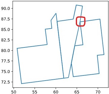
As soon as I split polygons by moving the point in the P2 to the left (65.75 becomes 65.7) the error disappears.
df = pandas.DataFrame({
    "name": ["P1", "P2", "P3"],
    "geometry": [
        "POLYGON ((60.05 88.85, 60.3 86.9, 61.9 73.4, 51.85 72.1, 50.8 80.5, 57.95 81.4, 57.5 85.05, 59.05 85.25, 58.85 87.15, 60.05 88.85))",
        "POLYGON ((66.35 90.55, 65.7 86.8, 64.5 81.1, 63.7 77, 63 73.55, 61.9 73.4, 60.3 86.9, 64.15 87.45, 64.85 90.8, 66.35 90.55))",
        "POLYGON ((65.75 86.8, 70.5 87.45, 71.45 79, 69.85 78.85, 70.3 74.5, 64.15 73.75, 63.7 77, 64.5 81.1, 66.45 81.35, 65.75 86.8))"
    ]
})

df['geometry'] = df['geometry'].apply(loads)
gdf = geopandas.GeoDataFrame(df, geometry='geometry', crs='EPSG:27700')
topo = tp.Topology(gdf, prequantize=False)
However, what puzzles me the most is that I cannot reproduce the error with only P1 and P2 or P2 and P3 as input data.
df = pandas.DataFrame({
    "name": ["P1", "P2"],
    "geometry": [
        "POLYGON ((60.05 88.85, 60.3 86.9, 61.9 73.4, 51.85 72.1, 50.8 80.5, 57.95 81.4, 57.5 85.05, 59.05 85.25, 58.85 87.15, 60.05 88.85))",
        "POLYGON ((66.35 90.55, 65.75 86.8, 64.5 81.1, 63.7 77, 63 73.55, 61.9 73.4, 60.3 86.9, 64.15 87.45, 64.85 90.8, 66.35 90.55))"
    ]
})

df['geometry'] = df['geometry'].apply(loads)
gdf = geopandas.GeoDataFrame(df, geometry='geometry', crs='EPSG:27700')
topo = tp.Topology(gdf, prequantize=False)
gdf.boundary.plot()

df = pandas.DataFrame({
    "name": ["P2", "P3"],
    "geometry": [
        "POLYGON ((66.35 90.55, 65.75 86.8, 64.5 81.1, 63.7 77, 63 73.55, 61.9 73.4, 60.3 86.9, 64.15 87.45, 64.85 90.8, 66.35 90.55))",
        "POLYGON ((65.75 86.8, 70.5 87.45, 71.45 79, 69.85 78.85, 70.3 74.5, 64.15 73.75, 63.7 77, 64.5 81.1, 66.45 81.35, 65.75 86.8))"
    ]
})

df['geometry'] = df['geometry'].apply(loads)
gdf = geopandas.GeoDataFrame(df, geometry='geometry', crs='EPSG:27700')
topo = tp.Topology(gdf, prequantize=False)
gdf.boundary.plot()

from topojson.
 robbibt
commented on May 28, 2024
robbibt
commented on May 28, 2024
Thanks @IvKor! It looks like your TypeError: cannot unpack non-iterable NoneType object error is slightly different from my TypeError: 'NoneType' object is not iterable, but it's quite possible they're slightly different versions of the same thing.
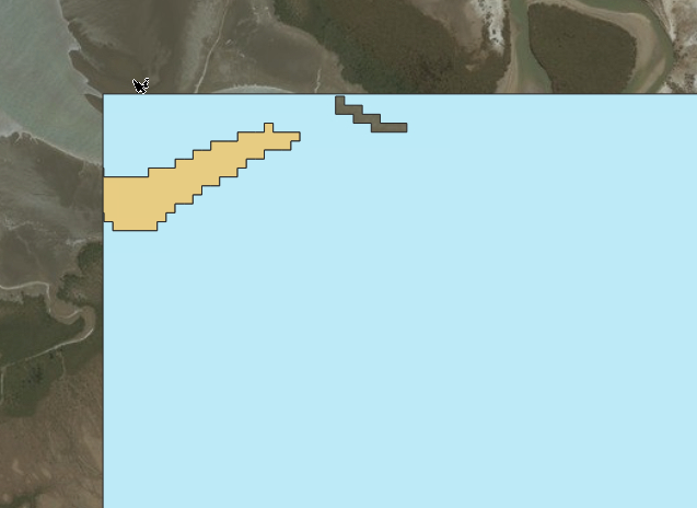
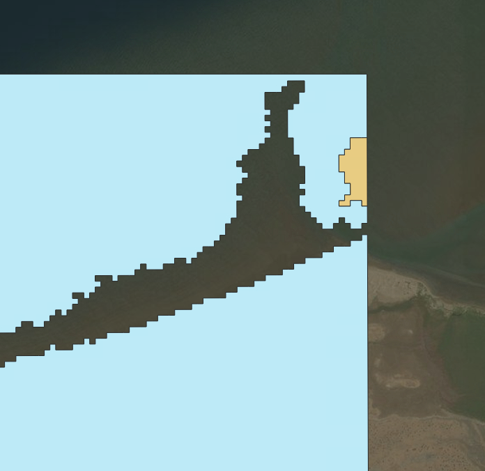
I've also tried to simplify my example down to a smaller set of three polygons - unfortunately one of them is still quite large, but at least it's a bit easier to manage. Like in @IvKor's example above, the error only occurs with three polygons, not two.
import topojson as tp
import geopandas as gpd

# Read file
gdf = gpd.read_file('polygons_subset.geojson')

# Construct topology and simplify
topo = tp.Topology(gdf, prequantize=False)
simplified_gdf = topo.toposimplify(30).to_gdf()
Error:
---------------------------------------------------------------------------
TypeError                                 Traceback (most recent call last)
<ipython-input-1-4c7209c7f772> in <module>
      6
      7 # Construct topology and simplify
----> 8 topo = tp.Topology(gdf, prequantize=False)
      9 simplified_gdf = topo.toposimplify(30).to_gdf()

~/.digitalearthau/dea-env/20200612/local/lib/python3.6/site-packages/topojson/core/topology.py in __init__(self, data, topology, prequantize, topoquantize, presimplify, toposimplify, shared_coords, prevent_oversimplify, simplify_with, simplify_algorithm, winding_order)
     99         options = TopoOptions(locals())
    100         # execute previous steps
--> 101         super().__init__(data, options)
    102
    103         # execute main function of Topology

~/.digitalearthau/dea-env/20200612/local/lib/python3.6/site-packages/topojson/core/hashmap.py in __init__(self, data, options)
     16     def __init__(self, data, options={}):
     17         # execute previous step
---> 18         super().__init__(data, options)
     19
     20         # execute main function of Hashmap

~/.digitalearthau/dea-env/20200612/local/lib/python3.6/site-packages/topojson/core/dedup.py in __init__(self, data, options)
     25
     26         # execute main function of Dedup
---> 27         self.output = self._deduper(self.output)
     28
     29     def __repr__(self):

~/.digitalearthau/dea-env/20200612/local/lib/python3.6/site-packages/topojson/core/dedup.py in _deduper(self, data)
     99             # apply linemerge on geoms containing contigious arcs and maintain
    100             # bookkeeping
--> 101             self._merge_contigious_arcs(data, sliced_array_bk_ndp)
    102
    103             # pop the merged contigious arcs and maintain bookkeeping.

~/.digitalearthau/dea-env/20200612/local/lib/python3.6/site-packages/topojson/core/dedup.py in _merge_contigious_arcs(self, data, sliced_array_bk_ndp)
    236                 # get the idx of the linestring which was merged
    237                 idx_merg_arc, consec_behavior = self._find_merged_linestring(
--> 238                     data, no_ndp_arcs, ndp_arcs, ndp_arcs_bk
    239                 )
    240

TypeError: 'NoneType' object is not iterable
from topojson.
robbibt
commented on May 28, 2024
Hey @mattijn , thanks for the reply and the great explanation! I've just tested out shared_coords=False, and had some mixed results. Both of my zipped geojson above work correctly with shared_coords=False, however @IvKor's simple example still fails.
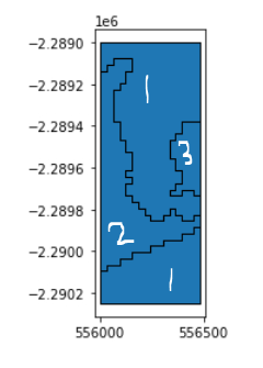
I've also run another similar analysis with shared_coords=False, and unfortunately hit the same issue. Here's another reproducible example for a small area containing three polygons:
import topojson as tp
import geopandas as gpd
import json

# Load JSON geometry
json_string = '{"type": "FeatureCollection", "features": [{"id": "0", "type": "Feature", "properties": {"certainty": 4}, "geometry": {"type": "Polygon", "coordinates": [[[556395.0, -2289375.0], [556485.0, -2289375.0], [556485.0, -2289735.0], [556455.0, -2289735.0], [556455.0, -2289705.0], [556395.0, -2289705.0], [556395.0, -2289735.0], [556335.0, -2289735.0], [556335.0, -2289705.0], [556365.0, -2289705.0], [556365.0, -2289675.0], [556395.0, -2289675.0], [556395.0, -2289615.0], [556365.0, -2289615.0], [556365.0, -2289555.0], [556335.0, -2289555.0], [556335.0, -2289465.0], [556365.0, -2289465.0], [556365.0, -2289435.0], [556395.0, -2289435.0], [556395.0, -2289375.0]]]}}, {"id": "1", "type": "Feature", "properties": {"certainty": 4}, "geometry": {"type": "Polygon", "coordinates": [[[556065.0, -2289075.0], [556155.0, -2289075.0], [556155.0, -2289135.0], [556125.0, -2289135.0], [556125.0, -2289195.0], [556095.0, -2289195.0], [556095.0, -2289225.0], [556065.0, -2289225.0], [556065.0, -2289375.0], [556095.0, -2289375.0], [556095.0, -2289465.0], [556125.0, -2289465.0], [556125.0, -2289525.0], [556155.0, -2289525.0], [556155.0, -2289615.0], [556125.0, -2289615.0], [556125.0, -2289645.0], [556155.0, -2289645.0], [556155.0, -2289675.0], [556125.0, -2289675.0], [556125.0, -2289735.0], [556155.0, -2289735.0], [556155.0, -2289765.0], [556185.0, -2289765.0], [556185.0, -2289795.0], [556215.0, -2289795.0], [556215.0, -2289825.0], [556245.0, -2289825.0], [556245.0, -2289855.0], [556305.0, -2289855.0], [556305.0, -2289825.0], [556335.0, -2289825.0], [556335.0, -2289795.0], [556365.0, -2289795.0], [556365.0, -2289825.0], [556395.0, -2289825.0], [556395.0, -2289855.0], [556455.0, -2289855.0], [556455.0, -2289825.0], [556485.0, -2289825.0], [556485.0, -2289885.0], [556455.0, -2289885.0], [556455.0, -2289915.0], [556425.0, -2289915.0], [556395.0, -2289915.0], [556395.0, -2289945.0], [556365.0, -2289945.0], [556305.0, -2289945.0], [556305.0, -2289975.0], [556275.0, -2289975.0], [556245.0, -2289975.0], [556245.0, -2290005.0], [556215.0, -2290005.0], [556155.0, -2290005.0], [556155.0, -2290035.0], [556125.0, -2290035.0], [556095.0, -2290035.0], [556095.0, -2290065.0], [556065.0, -2290065.0], [556035.0, -2290065.0], [556035.0, -2290095.0], [556005.0, -2290095.0], [556000.0, -2290095.0], [556000.0, -2289135.0], [556005.0, -2289135.0], [556035.0, -2289135.0], [556035.0, -2289105.0], [556065.0, -2289105.0], [556065.0, -2289075.0]]]}}, {"id": "2", "type": "Feature", "properties": {"certainty": 0}, "geometry": {"type": "MultiPolygon", "coordinates": [[[[556000.0, -2290095.0], [556005.0, -2290095.0], [556035.0, -2290095.0], [556035.0, -2290065.0], [556065.0, -2290065.0], [556095.0, -2290065.0], [556095.0, -2290035.0], [556125.0, -2290035.0], [556155.0, -2290035.0], [556155.0, -2290005.0], [556215.0, -2290005.0], [556245.0, -2290005.0], [556245.0, -2289975.0], [556275.0, -2289975.0], [556305.0, -2289975.0], [556305.0, -2289945.0], [556365.0, -2289945.0], [556395.0, -2289945.0], [556395.0, -2289915.0], [556425.0, -2289915.0], [556455.0, -2289915.0], [556455.0, -2289885.0], [556485.0, -2289885.0], [556485.0, -2290250.0], [556000.0, -2290250.0], [556000.0, -2290095.0]]], [[[556485.0, -2289000.0], [556485.0, -2289375.0], [556455.0, -2289375.0], [556395.0, -2289375.0], [556395.0, -2289435.0], [556365.0, -2289435.0], [556365.0, -2289465.0], [556335.0, -2289465.0], [556335.0, -2289555.0], [556365.0, -2289555.0], [556365.0, -2289615.0], [556395.0, -2289615.0], [556395.0, -2289675.0], [556365.0, -2289675.0], [556365.0, -2289705.0], [556335.0, -2289705.0], [556335.0, -2289735.0], [556395.0, -2289735.0], [556395.0, -2289705.0], [556455.0, -2289705.0], [556455.0, -2289735.0], [556485.0, -2289735.0], [556485.0, -2289825.0], [556455.0, -2289825.0], [556455.0, -2289855.0], [556395.0, -2289855.0], [556395.0, -2289825.0], [556365.0, -2289825.0], [556365.0, -2289795.0], [556335.0, -2289795.0], [556335.0, -2289825.0], [556305.0, -2289825.0], [556305.0, -2289855.0], [556245.0, -2289855.0], [556245.0, -2289825.0], [556215.0, -2289825.0], [556215.0, -2289795.0], [556185.0, -2289795.0], [556185.0, -2289765.0], [556155.0, -2289765.0], [556155.0, -2289735.0], [556125.0, -2289735.0], [556125.0, -2289675.0], [556155.0, -2289675.0], [556155.0, -2289645.0], [556125.0, -2289645.0], [556125.0, -2289615.0], [556155.0, -2289615.0], [556155.0, -2289525.0], [556125.0, -2289525.0], [556125.0, -2289465.0], [556095.0, -2289465.0], [556095.0, -2289375.0], [556065.0, -2289375.0], [556065.0, -2289225.0], [556095.0, -2289225.0], [556095.0, -2289195.0], [556125.0, -2289195.0], [556125.0, -2289135.0], [556155.0, -2289135.0], [556155.0, -2289075.0], [556065.0, -2289075.0], [556065.0, -2289105.0], [556035.0, -2289105.0], [556035.0, -2289135.0], [556005.0, -2289135.0], [556000.0, -2289135.0], [556000.0, -2289000.0], [556485.0, -2289000.0]]]]}}]}'
json_data = json.loads(json_string)

# Convert to GeoDataFrame
gdf = gpd.GeoDataFrame.from_features(json_data["features"])

# Construct topology and simplify (with shared_coords=False)
topo = tp.Topology(gdf, shared_coords=False, prequantize=False)
simplified_gdf = topo.toposimplify(30).to_gdf()
Error:
---------------------------------------------------------------------------
TypeError                                 Traceback (most recent call last)
<ipython-input-2-944ce03f791f> in <module>
     11
     12 # Construct topology and simplify
---> 13 topo = tp.Topology(gdf, shared_coords=False, prequantize=False)
     14 simplified_gdf = topo.toposimplify(30).to_gdf()

~/.digitalearthau/dea-env/20200612/local/lib/python3.6/site-packages/topojson/core/topology.py in __init__(self, data, topology, prequantize, topoquantize, presimplify, toposimplify, shared_coords, prevent_oversimplify, simplify_with, simplify_algorithm, winding_order)
     99         options = TopoOptions(locals())
    100         # execute previous steps
--> 101         super().__init__(data, options)
    102
    103         # execute main function of Topology

~/.digitalearthau/dea-env/20200612/local/lib/python3.6/site-packages/topojson/core/hashmap.py in __init__(self, data, options)
     16     def __init__(self, data, options={}):
     17         # execute previous step
---> 18         super().__init__(data, options)
     19
     20         # execute main function of Hashmap

~/.digitalearthau/dea-env/20200612/local/lib/python3.6/site-packages/topojson/core/dedup.py in __init__(self, data, options)
     25
     26         # execute main function of Dedup
---> 27         self.output = self._deduper(self.output)
     28
     29     def __repr__(self):

~/.digitalearthau/dea-env/20200612/local/lib/python3.6/site-packages/topojson/core/dedup.py in _deduper(self, data)
     99             # apply linemerge on geoms containing contigious arcs and maintain
    100             # bookkeeping
--> 101             self._merge_contigious_arcs(data, sliced_array_bk_ndp)
    102
    103             # pop the merged contigious arcs and maintain bookkeeping.

~/.digitalearthau/dea-env/20200612/local/lib/python3.6/site-packages/topojson/core/dedup.py in _merge_contigious_arcs(self, data, sliced_array_bk_ndp)
    236                 # get the idx of the linestring which was merged
    237                 idx_merg_arc, consec_behavior = self._find_merged_linestring(
--> 238                     data, no_ndp_arcs, ndp_arcs, ndp_arcs_bk
    239                 )
    240

TypeError: 'NoneType' object is not iterable
from topojson.
mattijn
commented on May 28, 2024
Thanks for trying! It’s now clear that current implementation (both strategies) is inadequate..
from topojson.
robbibt
commented on May 28, 2024
Hi @mattijn, this is great! How can I access the updated version? Will the fix be included if I do another pip install topojson?
Edit: I think this does the trick:
!pip install --user git+https://github.com/mattijn/topojson/
from topojson.
Related Issues (20)
- Topology modifies source data
- Topojson bbox should not be transformed when loading Topojson-dict HOT 1
- toposimplify wrongly applied on Topojson data from file
- Reduce decimal places when converting to GeoJSON HOT 2
- Shapely deprecation warnings in topojson 1.3 HOT 5
- Keep geojson properties HOT 6
- Merge multiple layers in a single topojson HOT 5
- Conversion to Typology object causes overlaps HOT 5
- tp.Topology.to_json(pretty=True) doesn't handle None correctly. (Doens't convert None to null) HOT 1
- Converting GeoJSON FeatureCollection to TopoJSON HOT 1
- BUG: `Topology.to_gdf` should keep the original index HOT 2
- holes in multipolygons are lost by simplification HOT 4
- Deprecation warning for shapely 2.0 HOT 3
- Wrong topologies/arcs being created? HOT 7
- Creating a topology for data without junctions and shared_coords=False, prequantize=False gives error
- Bug: polygons that entirely fill islands in another polygon are often not dedupped
- shared_coords=True vs shared_coords=False HOT 5
- Linestrings that follow the same path but where one contains extra redundant points are not deduplicated
- enh: include features that are possible with shapely 2.0
- tests failing, natural earth dataset changed HOT 2
Recommend Projects
-
 React
React
A declarative, efficient, and flexible JavaScript library for building user interfaces.
-
Vue.js
🖖 Vue.js is a progressive, incrementally-adoptable JavaScript framework for building UI on the web.
-
 Typescript
TypeScript is a superset of JavaScript that compiles to clean JavaScript output.
-
TensorFlow
An Open Source Machine Learning Framework for Everyone
-
Django
The Web framework for perfectionists with deadlines.
-
 Laravel
A PHP framework for web artisans
-
D3
Bring data to life with SVG, Canvas and HTML. 📊📈🎉
-
Recommend Topics
-
javascript
JavaScript (JS) is a lightweight interpreted programming language with first-class functions.
-
web
Some thing interesting about web. New door for the world.
-
server
A server is a program made to process requests and deliver data to clients.
-
Machine learning
Machine learning is a way of modeling and interpreting data that allows a piece of software to respond intelligently.
-
Visualization
Some thing interesting about visualization, use data art
-
Game
Some thing interesting about game, make everyone happy.
Recommend Org
-
Facebook
We are working to build community through open source technology. NB: members must have two-factor auth.
-
Microsoft
Open source projects and samples from Microsoft.
-
Google
Google ❤️ Open Source for everyone.
-
Alibaba
Alibaba Open Source for everyone
-
D3
Data-Driven Documents codes.
-
Tencent
China tencent open source team.
from topojson.