Giter Site home page Giter Site logo

os-openmap-local-stylesheets's Introduction

This repository contains stylesheets for OS OpenMap Local

Select the directory that matches the format of your data

Please note that in April 2023, there was a change to the data format of the geopackage for OS OpenMap Local. Please ensure you download the stylesheets that match the download date of your geopackage data.
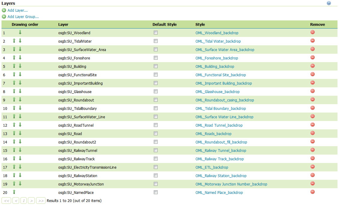
os-openmap-local-stylesheets's People

Contributors

charleyglynn avatar egil1978 avatar hwright-os avatar mpdaly avatar

Stargazers

 avatar  avatar  avatar  avatar  avatar  avatar  avatar  avatar  avatar  avatar  avatar  avatar  avatar  avatar  avatar  avatar

Watchers

 avatar  avatar  avatar  avatar  avatar  avatar  avatar  avatar  avatar  avatar  avatar  avatar  avatar  avatar  avatar  avatar  avatar  avatar  avatar  avatar

os-openmap-local-stylesheets's Issues

2 GeoServer directories in 'ESRI Shapfile stylesheets'

I suspect you noticed that the case was wrong and updated it...unfortunately git can be case insensitive when you don't want it to be (e.g. on Mac but not Windows)... 'ESRI Shapfile stylesheets/Geoserver stylesheets (SLD)' and 'ESRI Shapfile stylesheets/GeoServer stylesheets (SLD)'.

You might have to go all git command line on it: git mv --force filename Filename ...but don't take my word on that.

...and while i'm at it 'ESRI Shapfile'?

Sorry for the pedantry

Stylesheets for SVG

Having used your Master Map product for work, where there is an XSLT Style Sheet which can be used to transform the GML into SVG images it would be really useful if there was a simmilar stylesheet for these maps. I know this is a slower and more resource intensive approach for building maps, but in my view it offers the highest degree of customisablity as you can dynamically control what data appears in the GML, and you can control how the presentation of the maps work though instructions added to a "header" in the GML.

Geopackage ESRI Stylesheets

I am having a problem when working with the geopackage stylesheets within ESRI ArcMap 10.7.1.

I run through the supplied instructions as far as adding data and importing the LYR file.

When I go to the Layer Properties on any of the layers, on the Source tab the option for Change Source is not available, only Change Query.

I can only get Change Source when importing the regular ESRI stylesheet, but then the queries set within some of the layers do not work, because of the different field names.

Is anyone able to help?

Labels issue

The Open Map Local style sheets load the style but will not load the text labels in QGIS with sld or qml?

Roads, railways, not styling correctly in QGIS

Hi,

I'm using QGIS 2.18.10 and I am having problems with the styles for roads and railways in particular not being applied correctly. Here's a screenshot of what I'm seeing:

image

As you can see, the road casings are being shown, but the fills for roads and roundabouts are not being styled correctly. I have loaded in the QML files for these layers as you should be able to see in the layers panel.

There's also a missing railway track, which appears to not be styled either. It should be running from the top left where it says "West Channel" down to the bottom right through the clearly empty channel down the in the middle of the map.

I managed to get the named places to show by following the tip in issue #2, but I see that no actual fix has been provided for this issue in terms of an updated stylesheet. The issue was closed by the reporter though. Road labels don't appear to work either.

I suspect there are other layers that aren't be styled correctly in this version of QGIS too, but I haven't seen an area that I'm familiar enough with to know what's missing yet!

Is there anything I can do to get these styles working correctly? As things are, the maps I'm seeing in QGIS are lacking so many of the styles that I cannot adequately use them for any purpose :(

Thanks,

Dylan

Layer file with the raster label settings

The labelling on the raster version of this dataset is great. This is a bit of a long shot but is there a layer file available that contains the raster label settings that I can then apply to the vector data? Thanks

Geoserver stylesheets dont always work

When using the Geoserver stylesheets (SLD), there is a problem with either the stylesheet or the data with regard to the SU national grid square. On lines 308 to 3111 of OML_Roads_backdrop.sld there is a filter checking if "featureCod" equals 15749 (this condition is repeated 2 more times in other sections). When you load the SU tile data (as a shapefile) for roads into geoserver with this stylesheet the roads will not render because the attribute "featureCod" is missing from some of the features. I would have expected this to work (as clearly "the lack of featureCod makes it implicity not equal to 15749"), however in Geoserver (and geotools which I believe Geoserver uses), this causes a fatal error in rendering.

Recommended layer order

The recommended layer orders for different stylesheets do not agree.

LYR:

LYR

NB also has 'RoadFill' and 'RoadCase level 0', which the others don't

QML:

QML

SLD:

SLD

NB also missing 'CarChargingPoint', which the others have

Greyscale Option

These stylesheets are great, especially now that you've added advanced labelling for ArcMap users with Maplex.

Would it be possible to also share a gresycale or single-colour option alongside the backdrop colours?

CartoCSS format

Is it possible to make these available in CartoCSS format please?

Mapnik XML format

Is it possible to make these available in Mapnik XML format please?

Recommend Projects

  • React photo React

    A declarative, efficient, and flexible JavaScript library for building user interfaces.

  • Vue.js photo Vue.js

    ๐Ÿ–– Vue.js is a progressive, incrementally-adoptable JavaScript framework for building UI on the web.

  • Typescript photo Typescript

    TypeScript is a superset of JavaScript that compiles to clean JavaScript output.

  • TensorFlow photo TensorFlow

    An Open Source Machine Learning Framework for Everyone

  • Django photo Django

    The Web framework for perfectionists with deadlines.

  • D3 photo D3

    Bring data to life with SVG, Canvas and HTML. ๐Ÿ“Š๐Ÿ“ˆ๐ŸŽ‰

Recommend Topics

  • javascript

    JavaScript (JS) is a lightweight interpreted programming language with first-class functions.

  • web

    Some thing interesting about web. New door for the world.

  • server

    A server is a program made to process requests and deliver data to clients.

  • Machine learning

    Machine learning is a way of modeling and interpreting data that allows a piece of software to respond intelligently.

  • Game

    Some thing interesting about game, make everyone happy.

Recommend Org

  • Facebook photo Facebook

    We are working to build community through open source technology. NB: members must have two-factor auth.

  • Microsoft photo Microsoft

    Open source projects and samples from Microsoft.

  • Google photo Google

    Google โค๏ธ Open Source for everyone.

  • D3 photo D3

    Data-Driven Documents codes.