Giter Site home page Giter Site logo

hdm-cartocss's Introduction

hdm-cartocss's People

Contributors

bradh avatar cquest avatar danysan1 avatar harry-wood avatar mapmeld avatar mkoniecz avatar pnorman avatar skorasaurus avatar yohanboniface avatar

Stargazers

 avatar  avatar  avatar  avatar  avatar  avatar  avatar  avatar  avatar  avatar  avatar  avatar  avatar  avatar  avatar  avatar  avatar  avatar  avatar  avatar  avatar  avatar  avatar  avatar  avatar  avatar  avatar  avatar  avatar  avatar  avatar  avatar  avatar  avatar  avatar  avatar  avatar  avatar  avatar  avatar  avatar  avatar  avatar  avatar  avatar  avatar  avatar  avatar  avatar  avatar  avatar  avatar  avatar  avatar  avatar  avatar  avatar  avatar  avatar  avatar  avatar  avatar  avatar  avatar  avatar  avatar  avatar  avatar  avatar  avatar  avatar  avatar  avatar  avatar  avatar  avatar  avatar  avatar  avatar  avatar  avatar  avatar  avatar  avatar  avatar  avatar  avatar  avatar  avatar  avatar  avatar  avatar  avatar  avatar  avatar  avatar  avatar  avatar  avatar  avatar

Watchers

 avatar  avatar  avatar  avatar  avatar  avatar  avatar  avatar  avatar  avatar  avatar  avatar  avatar  avatar  avatar

hdm-cartocss's Issues

City names are often cut

See:

screenshot from 2013-06-07 00 01 40
screenshot from 2013-06-07 00 00 42

Certainly need to avoid the edges of the file for the big names (which are not "hyphenable").

Rendering runways of airfields (and airports)...

Obviously not a top priority!

Spotting the Ft. Liberte / Phaeton airfield on the map an old thought resurfaced:
Does it make sense to render the actual runway of an airfield (that are often quite restricted in what planes can land there)?

For me at least rendering them with the same quite strong and "asphalt like" grey seems too strong.
image

Many maps use simple symbols/icons to show airports and airfields (and they have separate icons for these two).
I think that ideally we would also show icons of both in lower zoom levels (now even the Ft. Liberte runway renders already at z11
image
-- I think the runway should not be shown at least before z15. Icon until then would be clearer. (perhaps for proper airports showing runway already at z13 is ok:
image

P.s. I like the Ubuntu Shift+PrntScrn w/ Github's paste image from Clipboard feature(s)

Creating a Legend

As @pierzen mentioned, this would be nice to eventually implement.

Any thoughts of how to design this or structure this ?

highway=secondary/tertiary/unclassified rendering

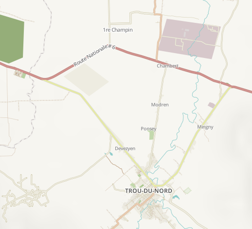
Currently the colors/rendering of secondary and tertiary highways seem to me to be the wrong way around in terms of "significance", This image
image
implies to me that the secondary road (old -- and actually still officially -- primary) road to Trou-du-Nord would be less significant than the tertiary roads to Caracol and south of TdN.

Now, I haven't yet fully figured out how the surface/smoothness(/practicability?) tags impact the rendering so I might be missing something (and this might be also a data issue). .. But it's clear that those roads don't currently render in a way that would reflect ground reality.

Ok. Looking a bit at the data it seems that the surface tag is taken in consideration and the default value is to show ways w/out surface tag as strong (same as paved).
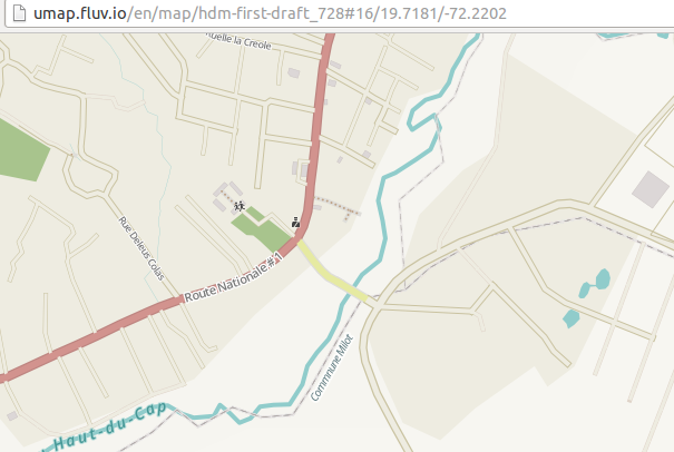
image

The secondary/tertiary roads should still be flipped the other way around, imo.

FOR UNCLASSIFIED:

I'd very much like to see some level of emphasis for unclassified vs. residential as it is the lowest level of the interconnecting road network (in urban areas). Now I know of only HikeBikeMap.de that would show the difference between residential/unclassified. And that's a pity because it doesn't encourage to tag properly -- nor to even understand that there is difference.

Examples (compare rue des Pins = unclssified and clear through road vs. rue Bailly = residential non-through road):
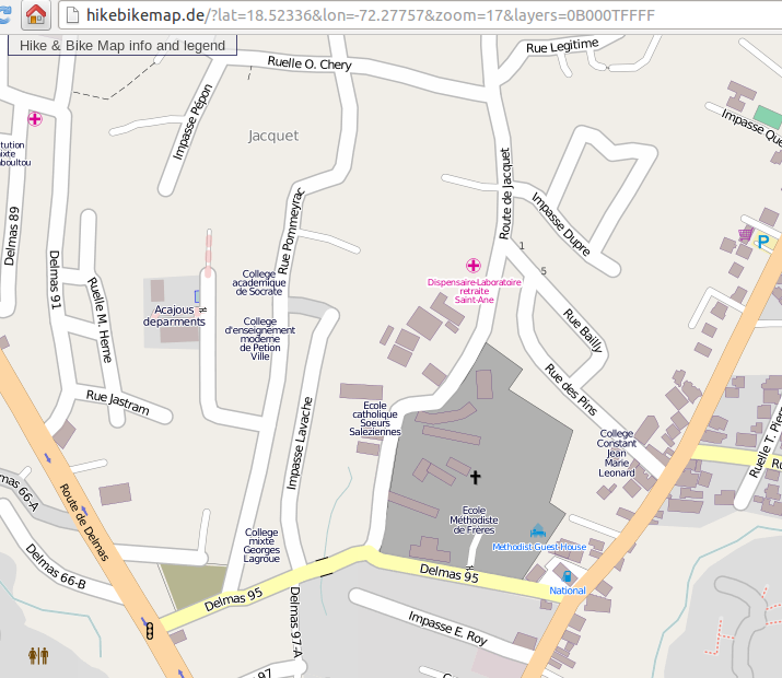
image

image

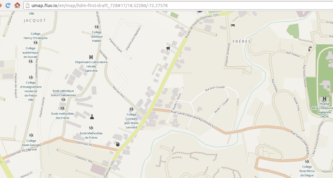
and then ... hmm. . the HOT Style actually shows the difference between unclassified and residential...
image
... but only if they are both surface=paved...

See rue Marie Therese next to HCH hospital in the right corner of the area (http://umap.fluv.io/en/map/hdm-first-draft_728#17/18.52375/-72.27561). That is an unpaved heavily used for through traffic unclassified road. .. HMm. I\m concluding that when it's unclassified it should show always more prominently than residential.
Thoughts?

Check extent

We must set all by hand, to avoid Mapnik querying for getting this value.

Prioritizing City Names to display at low zoom levels

selection_005

text-allow-overlap: is false By default in carto. and

In more dense areas, for example, you can have some city names (which are relatively more important than others - like Port au prince) not display because there are other place=city nodes in close proximity to each other.

For example, port au prince isn't displayed here - http://umap.fluv.io/en/map/hdm-first-draft_728#8/19.176/-73.378

To resolve this, I'd recommend using Dymo - https://github.com/migurski/Dymo

natural=beach

doesn't render. IMO it should. And so should surface=sand (which might be part of another tag like leisure=pitch when it's not so obvious if the sand value should have any impact.

Style name

I think that while the basis is the HDM it would be an awfully bad name for the rendering style.
I would suggest this to be "HOT Style" (or Humanitarian style). .. But I would prefer HOT Style both because it is not exactly humanitarian only, because it would nicely place HOT's name visible -- and it's spanking hot anyways!

Review greens

We have:

  • leisure=pitch
  • leisure=park
  • leisure=garden
  • leisure=playground (green?)
  • natural=wood
  • natural=scrub
  • natural=heath
  • landuse=forest
  • landuse=grass
  • landuse=farmland
  • landuse=farm
  • landuse=meadow
  • landuse=orchard
  • landuse=allotments
  • tourism=picnic_site
  • tourism=camp_site

At least, we should have a green for natural and one for human activities.

Recommend Projects

  • React photo React

    A declarative, efficient, and flexible JavaScript library for building user interfaces.

  • Vue.js photo Vue.js

    ๐Ÿ–– Vue.js is a progressive, incrementally-adoptable JavaScript framework for building UI on the web.

  • Typescript photo Typescript

    TypeScript is a superset of JavaScript that compiles to clean JavaScript output.

  • TensorFlow photo TensorFlow

    An Open Source Machine Learning Framework for Everyone

  • Django photo Django

    The Web framework for perfectionists with deadlines.

  • D3 photo D3

    Bring data to life with SVG, Canvas and HTML. ๐Ÿ“Š๐Ÿ“ˆ๐ŸŽ‰

Recommend Topics

  • javascript

    JavaScript (JS) is a lightweight interpreted programming language with first-class functions.

  • web

    Some thing interesting about web. New door for the world.

  • server

    A server is a program made to process requests and deliver data to clients.

  • Machine learning

    Machine learning is a way of modeling and interpreting data that allows a piece of software to respond intelligently.

  • Game

    Some thing interesting about game, make everyone happy.

Recommend Org

  • Facebook photo Facebook

    We are working to build community through open source technology. NB: members must have two-factor auth.

  • Microsoft photo Microsoft

    Open source projects and samples from Microsoft.

  • Google photo Google

    Google โค๏ธ Open Source for everyone.

  • D3 photo D3

    Data-Driven Documents codes.